|
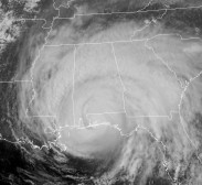
Hurricane
Katrina Chase Preparations
-Simon
prepares for the chase
Katrina
first made lanfall over the southeastern coast of Florida as a
minimal hurricane. But to everyone's surprise she barely weakened
as she traveled southwest over the moist Everglades. Katrina then
emerged early Friday morning over the record warm Gulf of Mexico
waters, just shy of hurricane status!
Within hours Katrina literally exploded and become a Category
2 Hurricane within hours. She stayed on a west-southwest course
longer than expected - surprising the NHC. Katrina is now officially
forecast to make landfall on Monday afternoon near the Mississippi/Alabama
border as a Category 4. Currently 1)water temperatures
over the Gulf of Mexico are at a record warmth in some areas 2)Upper
level shear is forecast to be low 3)Katrina is
already a Cat 2 Hurricane. With these conditions in place, Katrina
has the potential to make landfall as a Category 5 Hurricane!
Simon
is preparing himself for the worst. He plans to leave Norman,
Oklahoma Saturday evening to spend much of Sunday afternoon/evening
scouting the coastal areas for optimal chase locations. With sustained
winds near 140 mph, all precautions must be taken. He plans to
chain his car to another in the even Cat. 5 winds occur - which
could blow his and other cars away. He is also going to take a
chain saw in order to clear the road on his way home.
Hurricane
Katrina is going to be a historic storm; one which will probably
break a record for either damage or just shear intensity. We have
just entered the peak in the hurricane season and Katrina could
be the storm of the year!
Bottom
Line: Stomgasm will be there!
|
July
10 - Hurricane Dennis - 945mb Recorded
 |
July
10: Pace, Florida
Simon
measures pressure of 945mb in eye of Hurricane Dennis!
Video
clip now online!
Go
to Dennis page |
|
| June
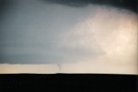
29 - Minnesota Tornado |
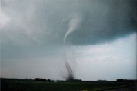 |
June
29: Minnesota
Simon captures a tornado in southern Minnesota. More photos here. |
| June
11 & 12 Tornadoes - Video Online
Video
clips are online, but photos have not yet been developed due to
time and other constraints. Photos will be online once circumstances
allow it.
|
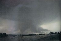
June
11:Texas Panhandle
Simon captures a large tornado over the southern Texas Panhandle.
Watch a sample clip here. |
 |
June 12: West Texas
Simon, Tom & Shawn track several tornadoes in west Texas.
Watch a sample clip here. |
|
| |
| June
6 & 9 Tornadoes
|
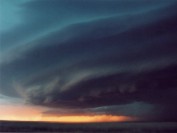
June
7: South Dakota
Simon gets a tornadic LP Supercell in Southwest South Dakota.
See more pics here. |
 |
Tornado
Video Online
June 9: Kansas
Simon tracks several tornadoes in Northwest Kansas. View
preliminary pics here. |
|
| |
| May
24 - Colorado Beauty
 |
Jim
views a great supercell in Eastern Colorado on his chase
vacation. View more photos here.
More
photos and info coming soon... |
|
| |
| Mammatus
in Kansas
 |
On
the way back from a bust in southwest Nebraska, these storms
in Kansas produced some of the most beautiful mammatus Simon
has ever seen. View more photos
here. |
|
| |
| Now
that Jim's scanner has been returned to him, he was finally able
to scan photos from the following days:
March
21 in SE Texas: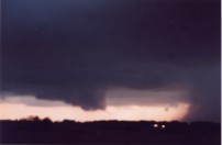
April
10 in central Texas: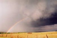 |
| |
|
|
Granada
Tornado Documentary - Wilber, NE
Granada
Productions is putting together a 30 minute tornado documentary
on 5 significant tornado outbreaks. Among these will be the May
22, 2004 Wilber/Hallam nebraska record breaking 2.5
mile wide tornado.
Update
- July 7
The
interviews in Nebraska were a great success and we are told the
documentary was on British television last week. We are awaiting
our copy of the show, and photos from interviews will be up soon.
|
| |
|
Manchester
Tornado Footage Airs on Discovery Kids Monday, 2 April 2005
If
you haven't had a chance to catch Stormgasm video on television,
you will have another chance at 3pm Eastern and Pacific time April
2nd. Click here to view sample
clips.
|
| |
|
Stormgasm
Tornado Footage Airs in the UK
On
Sunday, January 9th, 2005 UK's Channel 4 will air "7
Days that Shook the Weathermen".
The
program will air tornado footage captured by Stormgasm from May
8, May 9, and June 24 of 2003. Simon Brewer's incredible close
encounter with the Moore/OKC F4 tornado of May 8 will be shown.
Power flashes from the OKC nighttime tornado of May 9 will be
seen along with breathtaking, yet devastating, tornado footage
taken from South Dakota on June 24.
|
| |
|
Manchester
Tornado Footage Airs on the History Channel in October
The
History Channel has made a two part show on weather. The show
is called "Tactical to Practical", and the first segment
is called "Weather". Boring, right? Well segment two
is called "Extreme Weather". Sounds a little more interesting,
doesn't it?
Surely
this will prove to be a very entertaining show. The reason being
the History Channel is using one minute of video our footage in
this show! That's quite a bit of video to show from one source.
But what else can be said but it's great footage!
Keep
your eyes peeled for the air date and time, which should be sometime
in October.
|
| |
|
Stormgasm
Goes After Hurricane Frances!
What
has only been known as a lifetime dream for Simon Brewer will
become reality on Saturday, September 4th, 2004 as Hurricane Frances
makes landfall along the southeastern Florida coast. Simon, Reed
Timmer and Jole will attempt to capture video of what has caused
a large portion of Florida to declare a state of emergency.
On
Wednesday and Thursday Hurricane Frances was a very powerful hurricane
with maximum sustained winds of 140mph and showing now signs of
weakening. Frances had very favorable low wind shear conditions
with warm sea surface temperatures and little hope of weakening.
This resulted in forecasting an almost certain landfall as a category
4 hurricane or a strong category 3.
These
three now "hurricane chasers" hopped on a plane headed
for Fort Lauderdale, Florida Thursday night. They rented a car
and planned to review the latest information on Frances and find
a suitable shelter. When they left Thursday night they were prepared
for the ultimate pounding-nearly 24 hours of tropical storm force
winds, hurricane force winds for half that time, and a 1-2 hour
window of nearly 140 mph unrelenting Frances! This would be the
challenge of a lifetime; driving through blinding rain and 74+mph
winds while heading for the expected landfall of the eye.
But
since then things have changed. Frances has encountered a little
upper level wind shear and has had some drier air entrained on
the western side in the middle and upper levels. The eye of Frances
has also passed over some islands. The result has been the slow
weakening of Frances from 140 mph to 105 mph. Although, Frances
is expected to strengthen slightly as it reaches the warmer waters
just east of Florida. Nevertheless, this is simply not the same
beast Simon and the others were anticipating.
Major
hurricane or not, Frances is moving very slowly around 10 mph.
Having said that experiencing 100 mph+ winds for several hours
is still an incredible experience, one which most chasers dream
of. One can only hope Simon, Reed and Jole can make it out of
their safely after capturing video of an event they will never
forget.
|
|
|
|