March 20th, 2007 Capulin Volcano National Monument (New Mexico)

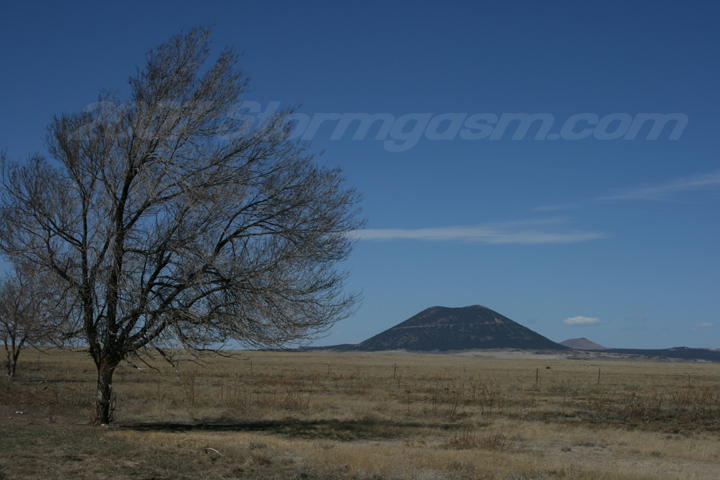
Simon Brewer and Anna Morrell made a trip on March 20th, 2007 to the Capulin Volcano National Monument in Northeastern New Mexico.

Simon: It was my birthday and I tend do an outdoor-type-activity on my birthday; last year (2006) I caught a tornado on a cold-core storm chase in Western Oklahoma, 2005 I climbed a small mountain in the Wichita Mountain Wildlife Refuge in Southwestern Oklahoma, 2004 I went hiking in the Wichita Mountains, 2003 I climbed the Chimney Tops Mountain in the Great Smokey Mountain National Park in eastern Tennessee.

This year I decided to check out the Capulin Volcano National Monument in northeastern New Mexico. I'd always wanted to check this area out, but never had the chance. I figured I would hit two birds with one stone and climb the highest point in Oklahoma; Black Mesa in the Western Oklahoma Panhandle, after going to Capulin. We didn't have time to do both, so we drove by Black Mesa and promissed to tackle that high point another day.

I've chased storms from the Rio Grand in Texas to Montana and North Dakota, but only once (May 15, 2003) had I crossed the New Mexico border, so I was pumped to plunge deep into New Mexico and walk on some extinct volcanoes on my birthday. Actually, as a child I was more fascinated (not significantly more fascinated, but slightly more fascinated) by volcanoes and earthquakes than weather. It's hard to describe my feelings when approaching Capulin, but they were intense! I'm talking about mixing deep childhood emotions with my current collegiate knowledge of geology.
We took SR 87 through northwest TX into northeast NM. We drove by extinct volcanoes like Rabbit Ear Mountain and Sierra Grande (an 8720 ft monster shield volcano) on the way to Capulin. The pic on the left shows Sierra Grande from the east; Capulin is completely blocked by Sierra Grande in this picture. The pic on the right shows Capulin Volcano from the east-southeast. Capulin is an extinct cinder cone volcano at 8,162 feet tall. Another volcano, Robinson Peak, is the brown extinct volcano behind Capulin.
The pic on the left is looking north at the south side of Capulin; a road spirals to the top of the volcano and can be seen as the thin line halfway up the mountain. The pic on the right is looking east at the west side of Capulin at the entrance to the park.
The road up Capulin has a steep grade and has hazardous cliffs off the edge of the road. The pics on the right and left show the road climbing up Capulin.
The pic on the left shows two small cinder cone volcanoes; the larger diameter crater on the left is 'Mud Hill', and the smaller crater on the right is 'Baby Capulin'. I believe that big black hill in the distance is Black Mesa. The pic on the right is from the parking lot on Capulin and shows the crater and crater rim. The crater is about 400 ft deep.
The pic on the right is from the parking lot and is a messy composite of pics taken and pieced together to show a 360 deg view of from the parking lot. The crater and rim and surrounding landscape can be seen in this large photo.
The pic on the left shows some extinct volcanoes southwest of Capulin; the big brown, dome-shaped volcano is called 'Horseshoe Crater'. The pic on the right shows Anna posing for me on the crater rim trail of Capulin. The crater rim trail is about a half-mile in length and completely follows the top of Capulin's crater rim. It ascends a few hundred feet to the highest point on Capulin.
We saw some wild life on Capulin; the pic on the left shows a lizard sun bathing on some lava rock. The pic on the right shows a dead tree sun bathing on Capulin's rim. I was surprised at the number of trees on Capulin, which make Capulin look nearly black from a short distance.
The pic on the left is looking southeast at big ol' Sierra Grande. The pic on the right is looking down into the crater of Capulin. The crater rim is lower on the west side and highest on the northeastern side of Capulin. Can you guess the direction the prevailing wind was blowing when Capulin erupted?
The pic on the left is looking nearly due north at the highest point on the crater rim; the paved crater rim path can easily be seen. The pic on the right is looking north at the crater rim.
The pic on the right is, again, looking down into the crater of Capulin.
The pic on the left is another shot lookining north toward the highest point on Capulin; the crater rim trail can be seen. The pic on the right shows the trees hugging the crater rim trail.
The pic on the left is the top of Capulin or at least the highest point on the crater rim trail. The pic on the right is me making a rediculous pose (for those familiar with Kevin Smith movies it is supposed to resemble the 'Buddy Jesus' pose).
The pic on the left shows Anna with Sierra Grande in the background. The pic on the right is looking northwest at Robinson Peak and the Sangre De Cristo Range covered in snow in the distance.
The pic on the left is looking down a small trail that descends into the crater of Capulin. There were still small patches of snow inside the crater in the shadows. The pic on the right is looking east from the bottom of the crater. It was really cool being inside the crater of a volcano. I would recommend to anyone traveling in this region to check out the Capulin Volcano National Monument.


Home | Storm Store | Photo Gallery | Message Board | Storm Chases | Latest News
Stock Footage | About | Contact | Editorial | Weather Links

All storm chasing (tornado, supercell, lightning, hail, sunset, ect.) photos and videos are copyright property of Jim Bishop and Simon Brewer (Stormgasm), unless otherwise specified. Any unauthorized reproductions are strictly prohibited by law.
Copyright 2004 Stormgasm.com. All rights reserved.